
Projects - Druid Hill Park Arch Scanning
Projects - Druid Hill Park Arch Modeling
Press Release - Druid Hill Park Arch Scanning
Direct 3Dview - Druid Hill Park Arch


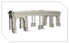
Baltimore's Druid Hill Park is one of the three oldest landscaped urban parks in the country (along with Central Park and Fairmount Park in Philadelphia) and is on the National Register of Historic Places. The impressive entrance arch was completed in 1868 and served as the main entrance to the park until it was separated from the park proper by the completion of Druid Park Lake Drive. In 1961 the arches, declared to be a traffic hazard, were almost torn down but locals were able to raise $14,000.00 for the preservation of the arch and demolition was avoided. Almost 50 years later the restoration efforts began with a day of 3D scanning.
The Druid Hill Arch is a perfect example of how our team was able to collect highly accurate data of a large monument in less than a day.

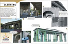
Step 1) A team of Direct Dimensions engineers and team members from John Milner Associates arrive on-site at approximately 8 AM to begin set up. Within thirty minutes they are ready to start scanning the arch.

Step 2) Using the portable Surphaser HSX Spherical Scanner the team was able to take over 20 scans in the next few hours. The Surphaser is perfect for architectural preservation projects because it can be taken anywhere (it can be carried on a plane) and is made to quickly and accurately scan mid-large range objects such as planes, vehicles and buildings.

Step 3) Our team finished scanning/data collection and was back in our office, aligning all the data by close of business the same day.

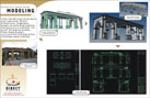
Step 4) Initial deliverables include plan views and elevations, but the data can also be used for physical reproductions, animations, renderings, virtual environments or anything else you can think of.